
Trace the Covington Street Directory
A useful street search moves from map evidence to record evidence. Begin with the exact address, including the southeast directional and any unit. King County iMap can locate an address, an intersection written with an ampersand, a place, or a parcel number. Its red parcel outline fixes the lot on the map. It does not name each person living there. Record the parcel number and legal description before moving to another system.
Follow a repeatable sequence so two lots with similar addresses do not become mixed. Keep a row for each parcel, and date every result. This by-address method works best as a research worksheet, not as a roster copied from one screen.
- Enter the full address in King County iMap and select the matching red-outlined parcel.
- Copy the parcel number, street form, plat, lot, and block shown in the map or linked record.
- Open King County Assessor eReal with the account or parcel number to review tax and sale clues.
- Search King County Recorder Landmark for the latest deed, then follow each seller backward as a prior buyer.
- Use permits, authorized voter-file access, or a covered reverse directory only for the narrower fact each source can establish.
The clean chain is address to parcel, parcel to assessment, owner to deed, and deed to prior owner. Voter and directory evidence stays separate because neither proves title. For a full named corridor, pan iMap one lot at a time and repeat the same steps for every parcel.
Browse Covington Streets in iMap
King County iMap is the practical map for a by-street survey. Basic Search accepts an address, parcel, landmark, or intersection. After choosing a suggestion, the viewer outlines the parcel. Pan along the road and click neighboring lots rather than assuming one result represents the whole block.
| Map control | Use along a street |
|---|---|
| Basic Search | Find an address, parcel, place, or street intersection |
| Suggestion and popup | Confirm the match and capture the parcel identifier |
| Layer List | Compare parcels, zoning, districts, and environmental layers |
| Basemap | Switch among county, aerial, vintage aerial, hillshade, and street views |
| Measure and select | Compare lot shape and distance without treating geometry as ownership |
Active layers matter. A zoning line, postal label, plat edge, and city boundary can occupy different places. Save the layer name and retrieval date with the parcel number. That makes a Covington street lookup reproducible when maps later change.
Note: Map adjacency identifies nearby land, not every occupant, family member, customer, or person who receives mail at an address.
Covington Parcel Search Fields
The King County Assessor eReal Property entry screen supports a property-tax account or ten-digit parcel number. Assessor guidance says a property record may supply values, characteristics, levy rates, and sale history. A public owner-name or direct street-address search was not confirmed on the inspected eReal screen, so use iMap to obtain the parcel key first.
| Field or control | Verified use | Limit |
|---|---|---|
| Property-tax account | Public search key | Must be known first |
| Ten-digit parcel number | Public search key | Older deeds may not carry it consistently |
| Street address | Accepted by iMap | Direct eReal control was not verified |
| Owner name | May appear with parcel data | Public name-search control was not located |
| Values and sale history | Described eReal content | Card labels can vary |
| Legal description | Bridge to recorded land records | Confirm against the deed or plat |
Three address concepts should never be merged. The situs address is where the parcel sits. The mailing address is where a tax notice goes, and it may be outside Covington. The legal description identifies the land by plat, lot, block, or metes and bounds. None proves who sleeps at the property.
Covington Street Directory Records
No public office maintains one complete Covington address roster. The closest result comes from joining address-keyed sources while respecting their different dates and meanings. The table shows both online routes and the fallback channels documented for each record.
| Address record | Custodian | What it can show | Access route |
|---|---|---|---|
| Parcel map | King County GIS | Lot location, geometry, layers, nearby parcels | iMap online; GIS contact if needed |
| Assessment | King County Assessor | Account, values, characteristics, sale and address clues | eReal, eSales, download, office, or records request |
| Recorded deed | King County Recorder and Archives | Parties, document date, legal description, liens, and plats | Landmark, mail copy order, Recorder counter, Archives microfilm |
| Permit or code file | City of Covington | Named project, inspection, notice, and public applicant fields | PermitTrax where exposed; City request or Permit Center |
| Voter record | King County Elections | Limited registration and participation fields | Individual tool or certified public-file request |
| Historical directory | SPL, State Library, and archives | Dated address-to-name snapshot when covered | Digitized pages, research room, librarian, or interlibrary route |
Utility customer data is not a public directory. Covington also contracts police service to the King County Sheriff's Office, so city staff do not hold or copy police and accident records. Route a named police record to the proper county or state custodian instead of adding it to a city request.
Follow Covington Deeds by Street
Landmark Records Search indexes King County recorded documents from 1976 forward, including deeds, easements, mortgages, liens, plats, and surveys. Most document images begin August 1, 1991. Search the present grantee, find the purchase instrument, note its recording date and legal description, then search that deed's grantor as a grantee in an earlier period.
Parcel indexing was inconsistent until about 2002. If a parcel search fails, try the full party name, a narrower date range, document type, and legal description. A negative parcel hit is not proof that no deed exists. Quitclaim, trustee, reconveyance, and estate instruments also may transfer an interest without representing a normal sale.
The successful manifest capture shows the official Landmark search interface used for that chain.
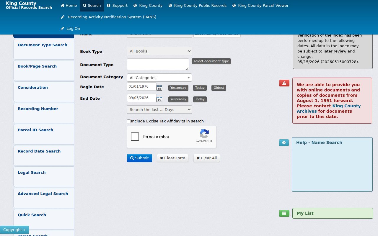
Use the search mode and date controls visible in the portal, then preserve the instrument number before moving backward to the next owner.
When Covington Deeds Leave the Web
The online cutoff is an access boundary, not a break in ownership. King County Archives preserves the General Recordings Index for 1853 through 1975 and older recorded material on microfilm. Researchers should bring a full name, a year or five-year window, and the parcel or legal description when possible. The Archives research room works by appointment, with customer service on weekdays and walk-in lobby hours on Tuesday and Wednesday.
King County Archives recorded-document guidance explains the older custody and research path. The Recorder also accepts mailed copy requests with its form and payment. Phone help is available from the Recorder at 206-477-6620 and Archives at 206-263-2480.
A 1976 to July 1991 index hit may lack an online image. Request the document rather than dropping the lead. Archives staff can also help locate older plat books and assessor context when a current parcel number does not appear in the historical index.
Note: Record the exact search method behind every no-result finding because name, parcel, image, and date coverage begin at different points.
Covington Road Names Over Time
Modern southeast-numbered roads preserve older local labels. The community history connects SE 240th with North Road, SE 256th with Middle Road, and SE 272nd with South Road. Kent-Kangley Road aligns with SR 516. Search both names when a deed, atlas, newspaper notice, or directory returns no current street match.
Covington incorporated on August 31, 1997. Earlier entries may describe unincorporated King County, a railroad or farm area, a precinct, or a nearby road rather than the modern city. There is no verified citywide renumbering list. Bridge an old address through a plat, legal description, road intersection, and the 1907, 1912, or 1936 regional atlases cited in the city's historic context work.
- Parcel
- A mapped unit of land identified by a county account number.
- Situs address
- The physical address assigned to the parcel, distinct from the tax mailing address.
- Plat
- A recorded map dividing land into named lots and blocks.
- Criss-cross directory
- A directory arranged by street and house number instead of only by surname.
Covington Plats Reshaped Streets
Aqua Vista Estates was filed in 1961 with 107 lots and a community beach at Pipe Lake. Other named plats from the 1961 to 1980 growth period include Suncrest Park, Timberlane Estates, Hart's Addition, and several later subdivisions. A filing date gives the earliest likely era for a legal lot. It does not prove a house was complete or occupied that year.
The 2023 Covington historic context statement reports that 98.55 percent of extant residential buildings were built since 1960. That number explains why assessor cards, plats, permits, and aerials often carry more street-level value than a nineteenth-century directory search. Nearly one-fifth of surviving homes date to the 1960s, with much of that decade's construction concentrated in 1968 and 1969.
Johnny's Food Center offers another dated address clue. It opened in 1961 and merged with QFC in 1994. Business names, subdivision names, and road aliases can help distinguish a location in regional newspapers, but they remain search terms until a record ties them to the parcel.
Covington Permits by Address
Covington Permit Services routes current permit work through PermitTrax and Citizens Connect. The public search fields and coverage start were not verified. When the portal does not expose a clear result, request a named address or parcel file through the Permit Center or the city's public-records channel.
The Permit Center offers appointments Monday through Thursday, 8 a.m. to 5 p.m., and can be reached at 253-480-2449. A permit can document work, inspections, and public applicant or owner fields. A code case may show a notice, status, and address. Neither source is a list of all people living at the property.
Describe the record narrowly in a request: address, parcel number, permit or case type, and date span. The City has five business days to respond under its Public Records Act procedure, though the response may acknowledge the request and provide a time estimate rather than the final records.
Covington Voter Street Limits
Washington permits access to selected voter-file fields under RCW 29A.08.710 through .740, but no casual public button produces every voter on a Covington street. Individual confirmation goes through VoteWA. A broader file request goes to King County Elections and requires the statutory use certification.
Public automated records may include a name, address, jurisdiction, year of birth, registration date, registration number, and participation history, subject to exceptions. Participation means whether someone voted, never the person's ballot choice. Social Security numbers, full birth dates, state ID numbers, original registration forms, and protected Address Confidentiality Program records are withheld.
King County Elections accepts requests online and by email, fax, mail, or through its Renton office. The office is open Monday through Thursday, 8:30 a.m. to 4:30 p.m., and its main number is 206-296-VOTE. Ask for the current fee and delivery format because neither was captured in the research.
Older Covington Street Directory Snapshots
A reverse directory can turn an old house number into a dated name, but Covington coverage is not continuous. The Seattle Public Library digitized selection covers selected regional directories from 1867 through 1940. Its 1928 Seattle House and Street Directory is the earliest address-keyed example identified by the library. It demonstrates the method, not guaranteed Covington coverage.
Washington State Library lists King County volumes for 1878, 1885/86, 1887, 1889, and 1911 through 1915. Check each volume for rural Covington-area inclusion. Ask a librarian for South King County catalog help when the web record is too broad. Older entries may use a farm name, crossroads, rural route, or unincorporated county label.
The collection itself, its gaps, and its abbreviation keys are treated in the Covington city directory material. Here, use the entry only as one date-stamped address clue and compare it with the plat and deed chain.
Limits of Covington Street Records
Parcel data identifies land and assessed ownership, not a household. A deed records an interest in property. A permit describes regulated work. A voter entry is an administrative snapshot governed by statutory restrictions. Even when all four point to the same address, they do not supply a complete list of residents.
Utility customer lists are not public resident directories. Driver address data is restricted, and protected voters are omitted. Recent transfers, name changes, data-entry variants, and delayed updates can also make two official systems disagree. Confirm a result with the office that created it.
Lawful use. Use Covington address records for legitimate personal research. Never use them to stalk, harass, intimidate, or expose a protected person.
A person-centered question should move to a named-record search, while a historical household question belongs with covered directory and census years. A by-street search remains strongest when it documents parcels, instruments, and dated public entries without claiming more than each record can prove.